Day Four: Stranraer to Glenapp
- David Gardiner
- Jun 11, 2021
- 5 min read
Today was very much a walk of two halves: coast and hill.


The day started with a decently early start. I slept very comfortably at the campsite, with the whole camping side of the site to myself. I treated myself to a hot shower (not an option tonight, but more on that later) and packed up the site after a cup of rose tea.

I walked into town, bypassing the official route, to head to the friendly Simpsons Bakery, where I bought a morning roll filled with bacon, square sausage, and scrambled egg. I walked to the coast and followed it east to the Gardens of Friendship, where I ate my purchased breakfast.
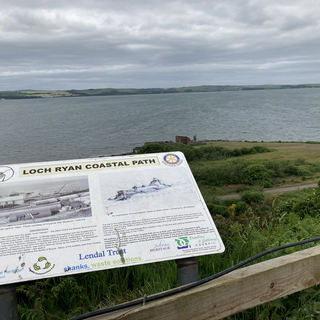
Thus feeling ready for the day in body and mind, I carried on east, following the coast. Shortly I came to the junction between Cairnryan Road and Ladies Walk, were the Mull of Galloway Trail meets the Loch Ryan Coastal Path. For me, the Mull of Galloway Trail was done; now I would be heading along the Loch Ryan Coastal Path to Glenapp.

The Loch Ryan Coastal Path is kind of an extension to the original Mull of Galloway Trail, with the intention of linking the latter to the Ayrshire Coastal Path, which begins at Glenapp.
Completing my first ‘trail’ felt good. It had been a hard 25 miles that my Fitbit reckoned to be rather a lot more; I hadn’t done it in the intended two days, but I had done it. Now the next trail ahead was a much shorter 10 miles: 5 along the coast to Cairnryan, then another 5 over the shoulders of the hills between Cairnryan and Glenapp.
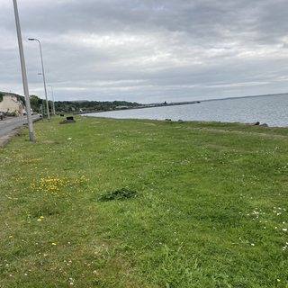
Stranraer is a town heavily focussed on the ferry traffic that used to come and go from the town harbour, but now operates through two terminals at Cairnryan, five miles closer to the mouth of the Loch. The dock infrastructure at Stranraer is still very much in place, but lends a sad, dishevelled look to the town shoreline. The main impression was of high, rusty security fences and storage for lorries.
The path out of the town is somewhat reminiscent of the beach paths on the Mull of Galloway Trail, but complemented by an excellent shared pedestrian and cycleway pavement. There’s well-spaced picnic sites, the second of which I was pleased to discover had a clean, well-maintained, accessible, and free unisex toilet for public use.


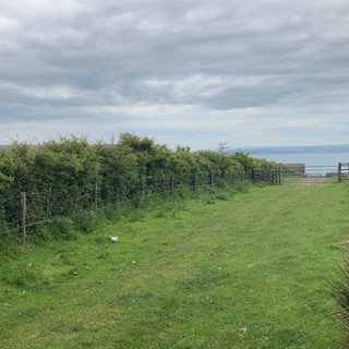
There were times the path was narrow, especially noticeable when weaving between 8-foot tall gorse and broom. Both are currently in full flower, and although I enjoy the coconut scent of gorse flowers, I was soon liberally coated in pollen. In contrast, there followed a section where some generous volunteer had strimmed a path four feet wide, which made walking much easier.


Cairnryan is of course dominated by the twin ferry terminals for P&O and Stenaline, especially as it is really just a village, but it actually has a very pleasant coastal village atmosphere. This sense of place was greatly helped by a long thin park running almost the whole length of the place, with frequently-spaced planters and benches. I met three folks working on the planters as I walked, weeding and planting new plants as they went along.


I took my lunch-break about half-way along that park, and watched a ferry arrive. These massive ships come in at quite some pace, and the swell they generate is not insignificant: indeed, there are warning signs about it all along the shore, encouraging the public to use Loch Ryan safely. When the waves had died down from the ferry’s passing, the waters of shore became a feeding ground for small birds, with swallows or house martins buzzing low for insects. I managed to catch a couple on video, I think.
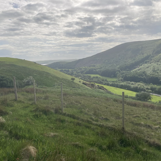
Moving on from lunch, the path up onto the hills came quickly after leaving the main residential area of Cairnryan. The path climbed steeply, and I focussed on taking shorter steps and using my trekking poles, and not rushing. As I climbed, the views grew ever better, and I was also treated to the arrival of a Stenaline ferry and the departure of the P&O ferry from earlier. The great ships move with surprising grace as they cancel their forward velocity, pivot, and gently reverse into the terminals.


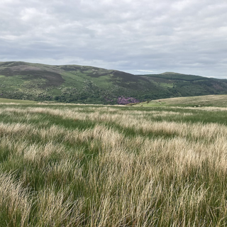
As I climbed, hard work as it was with the pack, I felt my heart lift surprisingly. I had been nervous about this steep section and the physical toll it might take, but as the landscape opened out in front of me it felt as if I was treated to a taster of the Highlands ahead north of Glasgow. It made me feel that even though the first section had been hard, the weeks ahead could be doable.
I stopped for a breather at my highest altitude for the day, about 575 feet, where an old gun battery had been installed (and since removed) to protect the shipping in the Loch in the Second World War, next to an ancient standing stone called the ‘taxing stone.’ According to tradition, the stone commemorates the burial of Alpin, king of the Scots of Dalriada, murdered in nearby Glenapp (site of tonight’s camping spot) in AD741.


The peace and quiet of that place was beautiful. The only sounds were the occasional bleats of sheep, the buzzing on insects, and the songs of skylarks. It was now about 3pm, so I joined my good friend Tom for the monastic minor prayer office of Sext via WhatsApp. Listening to Psalms and Acts and the recitation of prayers, all accompanied by those gentle sounds of nature, was a wonderful way to pray.
The path through the hills was not always easy. The track became the following of a dry-stone wall, and the occasional signs I followed did not agree precisely with either of the two slightly different representations of the route shown on different editions of the OS map, but it wasn’t particularly hard going. The one exception to that rule was a place that one of those gardening Cairnryan natives warned me of at lunchtime: a steep descent to cross a burn (stream) followed immediately by an equally steep ascent. I don’t particularly mind descending or ascending, but it feels like a waste of energy to do both in quick succession. Fortunately, although the footing crossing the burn was tricky, the steps down and up were excellent.


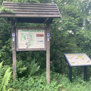
After that yo-yo experience, the path rejoined a forestry road, which led me down over the course of a mile to Glenapp church. It’s a really beautiful spot, with azaleas and wild and cultivated rhododendrons abounding. Just across the road from the church I officially finished the Loch Ryan extension to the Mull of Galloway Trail, and walked about a hundred yards of the Ayrshire Coastal Path (the next section of this journey) before finding my wild camping spot for the night.


The midges are out in force, but I have a comfy tent and the pleasant sound of a nearby burn (and the more ordinary sound of the A77) to lull me to sleep.

Tomorrow looks to be a relatively short, but still steep and almost entirely minor-road based eight miles to Ballantrae, where I will be staying in a B&B - my first actual bed since starting last week!
I hope you enjoy the pictures, and that the videos upload okay too. Good night!
Comments